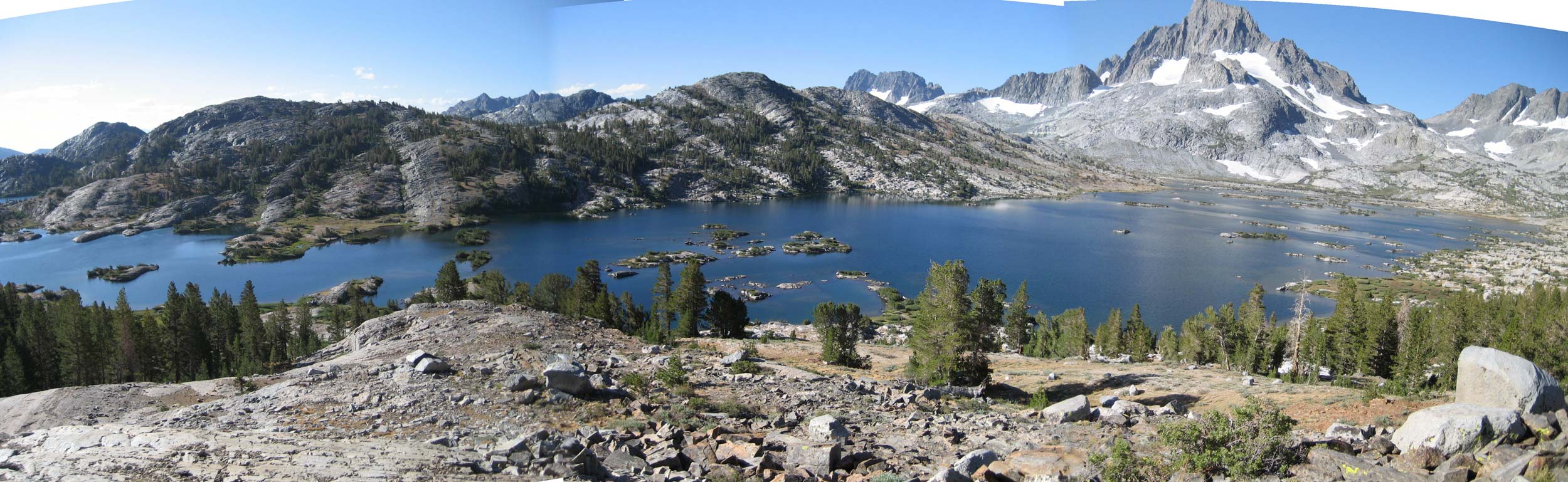
Thousand Island Lake below Mt Ritter
Originally called the Minarets Wilderness, it was renamed to honor photographer, Ansel Adams, in 1984. Covering over 230,258 acres, it contains incredible glacial valleys, high alpine lakes and peaks including the highest peak, Mt Ritter at 13,150 feet.
The wilderness is located southeast of Yosemite National Park and goes all the way south to Lake Thomas Edison. The John Muir Trail (JMT) (a portion of the Pacific Crest Trail (PCT)) passes through the heart of the wilderness. It can be reached from either side of the Sierra. The majority of backpackers enter the wilderness from the east, starting in the Mammoth Lakes area (near Devils Postpile National Monument), or from the south near Lake Thomas Edison at the Vermilion Valley Resort. It can also be accessed from June Lake, as well as, remote trailheads outside Oakhurst, CA. Permits are required for all overnight stays, and are avail from either Inyo or Sierra National Forest depending on where you begin your trip. See our detailed Sierra Wilderness Permit Page.
We offer the Central Sierra Trail Map to help you explore the Ansel Adams Wilderness area.
Trailheads
Rush Creek or Devils Postpile are the best access from the east, Mono Creek is best from the south
EASTSIDE —-
Rush Creek (7245′)
Parker Lake (7790′)
Gibbs Lake (7980′)
Devils Postpile at PCT (7500′)
WESTSIDE —-
Quartz Mountain (8230′)
Isberg (7130′)
Mammoth (7490′)
Jackass Lakes (7055′)
Calif Riding & Hiking (6570′)
French (6830′)
Rattlesnake (8090′)
Portal Forebay (7025′)
Mono Creek (7800′)
Campgrounds:
Includes campgrounds within striking distance of Ansel Adams Wilderness.
EASTSIDE —-
Silver Lake (7245′)
Agnew Meadows (8250′)
Upper Soda Springs (7690′)
Pumice Flat (7670′)
Minaret Falls (7610′)
Reds Meadow (7610′)
WESTSIDE —-
Granite Creek (6990′)
Clover Meadow (7030′)
Vermilion (7700′)
Bolsillo (7410′)
Mono Creek (7425′)
Mono Hot Springs (6560′)
-
 Central Sierra Trail Map$11.95
Transportation:
- A link to the Reds Meadow Shuttle from Mammoth Mountain (running mid-June to mid-September)
- Yosemite Area Rapid Transit in the Mammoth area….YARTS
- A Sierra Nevada Shuttles page — from climber.org
- Private trailhead transfer — from MAWS
- Another private trailhead transfer — from Sierra Shuttle Service
General Links:
- A list of the the best destinations in Ansel Adams Wilderness from The Outbound
- Tom Harrison Map of the Ansel Adams Wilderness
- Another nice write up about backpacking from Sonja Saxe
- Four must see day hikes from Wonder Farr
- Ansel Adams Wilderness page from Summit Post
- A link to the Inyo National Forest page
- Sierra National Forest Wilderness Page
- Detailed Info from Sierrawild.gov
-
 San Diego County Trail Map$11.95
 -
 Southern Sierra Trail Map$11.95
 -
 Mt. Laguna Trail Map$6.95
 -
Central Sierra Trail Map$11.95
-
 San Bernardino National Forest Trail Map$11.95